manturs.narod.ru
confluence.org

К моим визитам


14-июня-2025 – Едем на Кавказ в небольшой горный поход. По пути недалеко от дорог есть точка конфлюенции 46°N 44°E. Интрига заключается в том, что она находится на острове в солёном озере Цаган-Хаг. Предшественники, Oleg Pomogaev и serge romanowski в своём рассказе упомянули «участки, заполненные полусухим солевым раствором». Грязи. Есть проблема. Значит нам туда надо! Мы подготовились и взяли с собой коралловые туфли и сапоги.
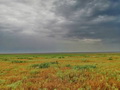
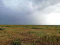
От Элисты поехали на Ставрополь в юго-западном направлении. Через 37 км свернули налево к посёлку Нарта. 5,5 км проехали по асфальту, дальше началась сухая глинистая полевая дорога. По дамбе пересекли реку Хара-Зуха, заехали в фермерское хозяйство. Фермеры указали дорогу к озеру (она хорошо видна на космоснимках). Припарковались на берегу протоки, которая отделяла нас от острова. Перед нами 100 метров грязи! Вечереет. Быстро надеваем сапоги и идём к слиянию. Первые метры показались простыми, на середине стали проваливаться. Надо идти, где меньше следов; ненарушенный верхний слой держит вес взрослого человека. Точка расположена в южной части острова. Делаем фото и быстро назад. Удивительный, необычный цвет заката.
На этом приключения не закончились… Ночуем на этом месте в палатках. С нами Svetlana Ptitsyna, которая может вызывать дождь даже в пустынях Калмыкии. Дождь шёл всю ночь. Утром 20 километров до асфальта мы выбирались почти 2 часа. Особенно трудно на мокрой глинистой дороге было автомобилю без полного привода.
Точка расположена в озере Цаган-Хаг, в Приютненском районе, а Республике Калмыкия. В 4,5 км на север находится ферма, в 12 км на северо-восток посёлок Амтя Уста, на таком же расстоянии на северо-запад посёлок Бугу. Социальная инфраструктура в них практически отсутствует: ближайшие учреждения: сельский клуб, библиотека, медпункт и средняя школа расположены в административном центре посёлке Нарта (15 км на северо-запад).
14-Jun-2025 – We are going to the Caucasus on a short mountain hike. On the way, not far from the roads, there is a confluence point 46°N 44°E. The intrigue is that it is located on an island in the salt lake Tsagan-Khag. Our predecessors, Oleg Pomogaev and serge romanowski, mentioned in their story "areas filled with semi-dry salt solution." Mud. There is a problem. So we need to go there! We prepared ourselves and took coral shoes and boots with us.
From Elista we went to Stavropol in a southwesterly direction. After 37 km we turned left to the village of Narta. We drove 5.5 km on asphalt, then a dry clay field road began. We crossed the Khara-Zukha River along a dam and stopped at a farm. The farmers showed us the way to the lake (it is clearly visible in space images). We parked on the bank of the channel that separated us from the island. There are 100 meters of mud in front of us! It is getting dark. We quickly put on our boots and go to the confluence. The first meters seemed easy, but in the middle they started to fail. We need to go where there are fewer tracks; the undisturbed top layer can support the weight of an adult. The point is located in the southern part of the island. We take a photo and quickly go back. An amazing, unusual color of the sunset.
The adventures did not end there… We spend the night in tents at this place. Svetlana Ptitsyna is with us, who can cause rain even in the deserts of Kalmykia. It rained all night. In the morning, it took us almost 2 hours to get 20 kilometers to the asphalt. It was especially difficult on the wet clay road for a non-four-wheel drive car.
The point is located in Lake Tsagan-Khag, in the Priyutnensky District of the Republic of Kalmykia. There is a farm 4.5 km to the north, 12 km to the northeast is the village of Amtya Usta, and the same distance to the northwest is the village of Bugu. There is practically no social infrastructure in them: the nearest institutions: a village club, a library, a medical center and a secondary school are located in the administrative center of the village of Narta (15 km to the northwest).
Пишите на |
||