manturs.narod.ru
confluence.org
К моим визитам
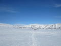
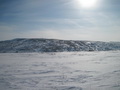
21-Марта-2017 – От начала маршрута мы на лыжах прошли уже больше 130км. От 66°N 62°E около 70км. Сегодня восьмой день похода. Лес и глубокий снег остались позади. В горах и тундре прочный наст, лыжи почти не проваливаются, идти легче. Мы преодолели два простых перевала Уральских гор и пересекли границу Европы и Азии.
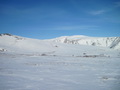
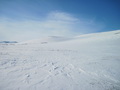
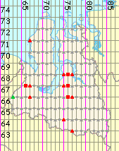
Точка расположена в Шурышкарском районе Ямало-Ненецкого автономного округа. Посёлок Епа расположен в 66км северо-западнее слияния. Примерно на таком же расстоянии на карте обозначены посёлки на юго-востоке, но не известно живут ли там люди сейчас.
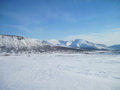
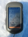
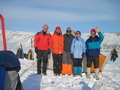
Отдыхаем и обедаем около точки конфлюенции. Программа посещений слияний закончена, но нам предстоит ещё пройти около 110км до станции Сивая Маска. Всего за поход пройдено на лыжах 240км.
21-Mar-2017 – We skied already more than 30 km from the start of the route. 66°N 62°E is about 70 km away. Today is the eighth day of the tour. We outwalked the forest and the deep snow. There is ice crust in the mountains and the tundra, so the skis don’t sink into the snow much, and it’s easier to ski. We passed two simple mountain crossings in the Urals and crossed the border between Europe and Asia.
The point is situated in Shuryshkarsky region of Yamalo-Nenets Autonomous Okrug. The village of Yepa is 66 km NW of the confluence. The map shows some villages SE at about the same distance, but we don’t know if they are inhabited.
We take our rest and have lunch near the confluence point. No more confluence points to visit. But we still have to walk about 110 km to the Sivaya Maska station. We have skied about 240 km in this tour.
Пишите на |
||