manturs.narod.ru
confluence.org

К моим визитам
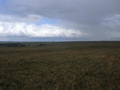
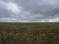
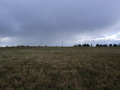
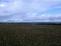
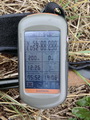
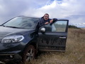
10-Сентября-2016 – Прогноз на неделю – дожди. И вдруг утром солнце, редкие красивые облака. Еду на точки. Плохая дорога на границе Удмуртии и Татарстана. От Грахово до села Порым проложен асфальт. За селом скользкая, мокрая глинистая грунтовка. От парковки до точки конфлюенции 250 метров. Начинается дождь. После посещения, подхожу к машине, дождь прекращается. Невезуха. Еду дальше к 56°N 53°E. Грунтовка, грейдер, асфальт. И тут начинается ливень. «Дворники» не успевают очищать лобовое стекло, снижаю скорость. Значит на точке мне очень повезло с погодой.
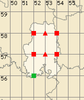
Точка находится в Гроховском районе республики Удмуртия. Ближайший населённый пункт, село Порым находится в 760 метрах восточнее. Местность равнинная. Вероятно, что раньше здесь были поля, сейчас здесь пасут скот. Грунт глинистый и в сырую погоду лучше ехать по краю поля.
10-Sep-16 – The weather forecast said it would be raining that week. All of a sudden, it was sunny in the morning, there were scarce and beautiful clouds in the sky. I was driving towards the confluence points. The road at the border between Udmurtia and Tatarstan is in bad condition. There is an asphalt road from Grahovo to Porim village. Behind the village there was a wet slippery clayish dirt road. From the place where I left my car to the 56°N 52°E confluence point there were 250 meters. It was starting to rain. I visited the confluence point and went back to the car. At the moment I came back to the car the rain stopped-such a bad luck! I drove on towards the 56°N 53°E confluence point. There was a dirt road followed by an unpaved road and by an asphalt one. After some time the downpour suddenly started. The wiper blades couldn't sweep water away from the windscreen in time, so I decreased the speed of the car. I concluded I had been very lucky with the weather at the confluence point.
The confluence point is located in Grakhovsky District in the Udmurt Republic. The nearest inhabited locality is Porim village located 760 meters to the east of the confluence point. The landscape is flat. Probably, there were fields before, now there are cow pastures. The soil is clayish, so in wet weather it is better to drive along the edge of the fields.
Пишите на |
||