manturs.narod.ru
confluence.org

К моим визитам


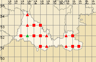
17-июня-2023 – После посещения 52ºN 51ºE я отправился на следующее запланированное слияние 52ºN 53ºE. Яндекс предложил два варианта: через Первомайский – Рубежинский – Ташла, вдоль границы с Казахстаном. Второй: через Нефтегорск – Бузулук – Сорочинск, по трассе М-5. Выбрал второй, он и на сто километров длиннее, но надёжней. Планировал добраться до точки и заночевать там.
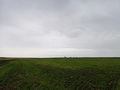
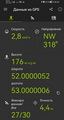
Положился на Яндекс, съехал с асфальта на просёлок. Через 800 метров возникли проблемы с пересечением верховий речки Каменная. Аккуратно проехал. Вдоль оврага дороги нет, объехал поле южнее и остановился в 500 метрах. Слияние нашёл в 20:30. Объехал овраг по верховьям и заночевал в ближайших посадках.
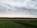
Точка расположена в Ташлинском районе, Оренбургской области, в 2,6 км западнее села Благодарное. Местность пересечена небольшими оврагами, вокруг поля посадки. На выезде с асфальтовой дороги установлены таблички о запрете охоты без разрешений. Ночью ко мне подъехали егеря и поинтересовались наличием оружия в машине.
Утром я отправился к слиянию 52ºN 55ºE.
17-Jun-23 – After visiting 52ºN 51ºE, I headed to the next planned confluence point, 52ºN 53ºE. Yandex suggested two routes: one through Pervomayskiy - Rubezhinskiy - Tashla, along the border with Kazakhstan, and the other through Neftegorsk - Buzuluk - Sorochinsk, along the M-5 highway. I chose the second option, even though it was a hundred kilometers longer, as it seemed more reliable. I planned to reach the point and spend the night there.
Relying on Yandex, I turned off the asphalt onto a dirt road. After 800 meters, I encountered difficulties crossing the headwaters of the Kamenaya River. I managed to pass carefully. There was no road along the ravine, so I went around the field to the south and stopped 500 meters away. I found the confluence at 8:30 PM. I circumvented the ravine along its upper reaches and camped in the nearest grove.
The point is located in the Tashlinsky district, Orenburg region, 2.6 km west of the village of Blagodarnoye. The area is crossed by small ravines, with fields surrounding the groves. Signs prohibiting hunting without permission are installed at the exit from the asphalt road. At night, gamekeepers approached me and asked about the presence of weapons in the car.
In the morning, I headed towards the confluence point 52ºN 55ºE.
Пишите на |
||