manturs.narod.ru
confluence.org

К моим визитам
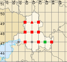
15-Августа-2010 – Продолжение от 46°N 42°E.
Мы проехали 4,5 км на запад, и вышли на асфальт. Далее через Городовиковск и Сальск добрались до посёлка Зимовники. От него повернули в направлении Элисты и от хутора Глубокий свернули на восток, к слиянию. На космоснимках «Google» и топокартах точка расположена в середине водоёма и её посещение было под вопросом. Однако времени было достаточно, лето стояло аномально жаркое, был шанс подойти к месту слияния поближе. Мы решили рискнуть.
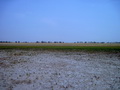
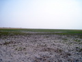
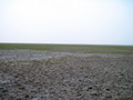
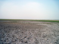
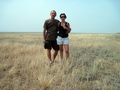
Точка расположена в Зимовниковском районе Ростовской области в 4,5 км от хутора Котов. Рельеф – равнинный, степной. Степь не распахана и используется под пастбища. Лесопосадок мало. Местность имеет промежуточный вид между полупустынями востока Калмыкии и полями Ставрополья. Подъехав к точке конфлюенции, мы были несколько удивлены тем, что не увидели водоёма обозначенного на картах. Озеро полностью высохло за лето и до точки мы без проблем дошли пешком.
Долго задерживаться здесь мы не стали и отправились к точке 47°N 41°E.
15-Augl-2010 – Continued from 46°N 42°E.
From the previous confluence we covered 4.5 km to the west and came back to asphalt road. Then we got to Zimovniki settlement through Gorodovikovsk and Sal'sk towns. From Zimovniki settlement we turned to Elista town, then from Glubokiy village we turned to the east towards the confluence. The CP is located in the centre of a lake according the map and the GE satellite photo. And the visit to this confluence was up in the air. We had plenty of time and the summer was abnormal hot, so we had a chance to come close to the place of degree confluence. We decided to take the chance.
The confluence is located in Zimovnikovsk district of Rostov region, in 4.5 km from Kotov village. Relief is plain and steppe. The steppe is not ploughed and used for pasture. Forest plantations are few. The plain is medium between Eastern Kalmykia semidesert and a Stavropol' territory's fields. When we drove up to the confluence point, we were surprised that we did not see a lake which is marked on our map. The lake dried up at all during the summer and we reached the confluence on foot without any trouble.
We did not stay here a long time and went further to 47°N 41°E.
Пишите на |
||