manturs.narod.ru
confluence.org

К моим визитам
13-Августа-2010 – Продолжение от точки 47°N 46°E.
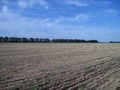
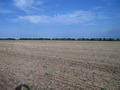
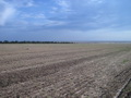
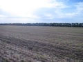
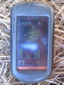
Сначала мы хотели проехать до точки конфлюенции 45°N 44°E, но немного задержались в Элисте и у села Дивное были уже вечером. Решили посетить ближайшую отсюда точку 46°N 43°E. Доехали до села Манычское, свернули на просёлочную дорогу. От асфальта до точки 18 километров хороших, укатанных полевых дорог. Точка расположена на поле в 500 метрах от дороги. Хорошо, что уже собрали урожай, удалось выехать на машине прямо на место.
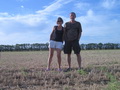
Точка расположена в Апанасенковском районе Ставропольского края в 4,8 км от села Белые Копани. Рельеф местности – равнинный, степной. Степь практически вся распахана. Вокруг полей посажены лесополосы. Сёла утопают в зелени, много садов. Ставрополье разительно отличается от Калмыцкой степи. Высота местности над уровнем моря 50-110 метров. Это – отроги Ставропольской возвышенности, ограничивающие Манычскую впадину.
После ночёвки в Светлограде мы отправились к точке 45°N 44°E.
13-Augl-2010 – Continued from 47°N 46°E.
Firstly we intended to go to the confluence point 45°N 44°E, but we stayed too long in Elista city and reached Divnoye village only by the evening. We decided to visit the nearest point 46°N 43°E. We drove to up to Manychskoye village and turned to the country road. From the asphalt road to the confluence point there are 18 km of good and smooth dirt field roads. The CP is situated in the field, in 500 meters from the road. We were lucky: the harvest had been already gathered and we could drive straight to the confluence spot by the car.
The confluence is in Apanasenkovskiy district of Stavropol' territory, in 4.8 km from Belyye Kopani village. The terrain is flat steppe. Almost all the steppe is tilled. There are forest belts around the fields. There are plenty of gardens everywhere: the villages seem to be buried in verdure! Stavropol' territory much differs from Kalmyk steppes. The height above the sea level is 50–110 meters: these are branches of Stavropol' Upland, which bound Manychskaya Depression.
We spent a night in Svetlograd and then set off towards the confluence 45°N 44°E.
Пишите на |
||