manturs.narod.ru
confluence.org

К моим визитам
5-Августа-2016 – Первым этапом путешествия по Грузии было восхождение на гору Казбек (5033,8 м). После успешного завершения этого этапа группа разделилась. Наша команда поехала реализовывать программу-максимум – открытие точки конфлюенции 42N-46E.
По пути осматриваем достопримечательности Грузии, Тбилиси, Кахетии. Грузия –восхитительная страна! Наша цель село Ахалсопели в Кахетии.
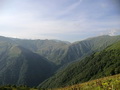
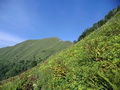
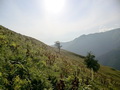
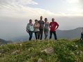
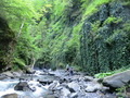
От трассы мы проехали на северо-западную окраину села. Оставляем машину на пасеке, а сами отправляемся вверх по долине Аванискхеви. Решаем подниматься по пути, упомянутой Todd. Проходим впадение небольшой речки Квитзеристскали. Дорога идёт по левому борту реки Аванискхеви и постепенно переходит в тропу. На ночлег останавливаемся на ровной площадке в 200 метрах от второго притока. За водой приходится спускаться по крутому склону. До машины 4 км, до точки 3,7 км по прямой. Утром продолжаем движение вверх по реке. Ландшафт меняется, вокруг скалы, лианы, заросли ежевики. Попадаем в «затерянный мир», кажется, что из-за угла вот-вот появится динозавр. Тропа часто теряется, приходится делать разведки. Несколько раз переходим реку вброд. Изредка проявляется присутствие людей в виде следов и оставленного мусора. Третий крупный приток ведёт прямо к 42N-46E. Здесь начинается каньон. По очень крутым склонам поднимаемся на отрог хребта. До точки всего 3 км. Крутые склоны, заросли колючих растений, жара, отсутствие воды. Подъём от ночёвки занимает почти 10 часов! Ближе к вечеру приходит мысль об отступлении. В 700 метрах от слияния оставляем рюкзаки и идём налегке. Находим старый кош, в 300 метрах от него родник. Есть новая конфлюенция! Бежим к воде, пьём, пьём, пьём, потом за рюкзаками. Ночуем у коша.
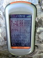
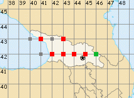
Точка расположена в восточной Грузии, в Кварельском муниципалитете края Кахетия. Ближайший населённый пункт – Ахалсопели в 9,5 км на север-северо-западе.
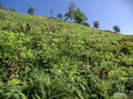
На юго-востоке от нашего лагеря виден ещё один кош. От него по параллельному отрогу идёт тропа. Решаем спускаться по ней. Тропа хорошо заметна, по ней ходят. Иногда приходится продираться через заросли борщевика выше человеческого роста. Тропа обозначена на российских военных топографических картах. Спуск до машины занял 4 часа.
Подниматься к слиянию лучше по пути нашего спуска. Тропа отходит от дороги сразу после слияния Аванискхеви и Квитзеристскали. Ориентир – развалины монастыря Tavtsminda Giorgi.
5-Aug-2016 – The first part of our trip to Georgia consisted of the Mount Kazbek climb (5033,8 m). After the successful completion of that part our group was split. Our team set off to achieve an ultimate goal-to visit the confluence point 42N-46E which had not been visited before.
Along the way to the confluence point we stopped in Tbilisi and at several places in Kakheti for sightseeing. Georgia is a wonderful country! Our destination was the village Akhalsopeli in Kakheti.
We left the route and went to the northwest edge of the village. We left our car at an apiary and went up through the Avaniskhevi valley. We decided to go up via the route mentioned by Todd. We passed an inflow of a small river called Kvitzeristskali. The route goes on the left side of the Avaniskhevi river and gradually turns into a trail. We stopped for a night on a flat area 200 meters away from the second inflow. To fetch water it was necessary to go down a steep slope. We were 4 km away from the car and 3,7 km away from the confluence point (a straight-line distance). The next morning we continued going up the river. The landscape gradually changed: there were rocks, liana, blackberry bushes around. We found ourselves in "the lost world", it seems that a dinosaur is going to walk around the corner in a moment. The trail was often lost, so it was necessary to go exploring to find it again. We had to wade the river several times. Once in a while we came across human footprints and abandoned garbage, so there had been people in this location before. The third inflow, bigger one, leads directly to the 42N-46E confluence point. We ended up standing at the bottom of a canyon. We climbed up a very steep slope to the ridge spur. We were only 3 km away from the confluence point. The slopes were very steep, there were a lot of thorny plants around; in addition, it was very hot and there wasn't any water source nearby. The climbing from our overnight stay took almost 10 hours! As the evening approached a thought about the retreat emerged. We left our backpacks 700 meters away from the confluence point and went up to the destination. On our way we came across an old shepherd hovel and a water spring located 300 meters away from the hovel. We visited the confluence point! Then we ran to the spring and drank-drank-drank, then we came back to take our backpacks. We stayed for a night near the hovel.
The confluence point is located in Eastern Georgia, in the Kvareli Municipality of the Kakheti region. The nearest inhabited locality is Ahalsopeli located 9,5 km north-northwest of the confluence point.
There was another shepherd hovel situated southeast of our night camp. There is a trail running on the parallel spur from that hovel. We decided to take this trail to go down. The trail is easily noticeable, it's clear that people are using it. Sometimes we had to force our way through cow parsnip thickets taller than a man.The trail is marked on Russian military topographic maps. The descent to the car lasted 4 hours.
It is better to go up to the confluence point along the trail that we used for going down. The trail branched off the road just after the confluence between Avaniskhevi and Kvitzeristskali rivers. The Tavtsminda Giorgi monastery can be used as a reference point.
Пишите на |
||