manturs.narod.ru
confluence.org

К моим визитам
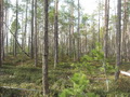
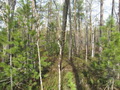
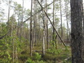
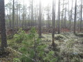
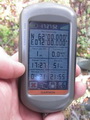
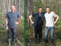
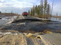
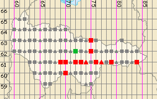
15-Мая-2014 – Точка конфлюенции расположена в 40 км севернее посёлка Лянтор в Сургутском районе Ханты-Мансийского автономного округа. Это пойма реки Пим. Вдоль реки проходит дорога, ведущая к посёлку Нижнесортымский и дальше к нефтяным месторождениям. Проехав 62 параллель, свернули на запад к кустовой площадке №604. От куста до точки 870 метров пешком по прямой. Летом это место вероятнее всего сухое, об этом говорят натоптанные тропинки. Мы встретили на пути две водные преграды, старые заросшие русла реки. Удалось перейти их в сапогах, не замочив ног. В самом слиянии упавшие деревья образовали крест, символизирующий пересечение. Вернувшись к машине, мы выехали на дорогу и продолжили путь на месторождение. Проехать туда в этот день не удалось, прямо у нас на глазах размыло дорогу и пришлось вернуться в Когалым.
15-May-2014 – The confluence is located 40 kilometers from Lyantor settlement in Surgut district of Khanty-Mansiyskiy autonomous okrug [territory] in a floodplain of Pim river. The road along the river leads to the Nizhnesortymskiy settlement and further on to the petroleum deposits. When we passed 62nd parallel, we turned to the west to the cluster site №604. To reach the confluence from here you need to go 870 meters on foot. In the summer this place should be dry, even now one can notice several beaten paths. On our way we ran into two water obstacles, namely old overgrown stream beds. We managed to cross them without getting our feet wet. In the confluence point two fallen trees formed a cross, symbol of degree meeting. As soon as we returned to the car we drove onto the road and continued our way to the deposit. That day we did not manage to reach it. The road. The road right beneath our own eyes. We had to return to Kogalym town.
Пишите на |
||